
Galveston Island
 Galveston Island
is a barrier island off the coast of Texas. How is a barrier island
formed? Initially, the inhabitants were snakes and wild animals. The
Karankawa Indians were there to meet Estevanico and Cabeza
de Vaca in 1528.
Galveston Island
is a barrier island off the coast of Texas. How is a barrier island
formed? Initially, the inhabitants were snakes and wild animals. The
Karankawa Indians were there to meet Estevanico and Cabeza
de Vaca in 1528.
Bernardo de Galvez, Spanish viceroy in Mexico City, sent a man to map that area of the Gulf of Mexico. This navigator, Jose de Evia, named a bay after Viceroy Galvez. The name was later extended to the island, the city, and the county. When did the Spanish flag fly over Galveston?
Jean Lafitte made the island his headquarters after being chased out of New Orleans. He built a red stone house called "Maisson Rouge" inside a fort constructed by his men. He stayed from 1817 to 1821. Jean Lafitte was a privateer. How is that different from a pirate or buccaneer?
Stephen F. Austin, in 1825, declared Galveston "the best natural harbor" he had seen and so the island's present-day history began. How many years ago was that? Austin needed a place for his settlers to disembark if they chose to come by ship. Name as many countries as you can that were the original home for the immigrants to Texas.
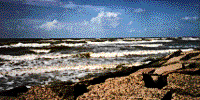
 The picture you see here is the sea wall at Galveston begun in 1902. It
runs over ten miles along the coast of the Gulf of Mexico and was completed
a piece at a time. The last piece was finished in 1962. Can you think
of something else that looks like this wall?
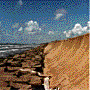
The picture you see here is the sea wall at Galveston begun in 1902. It
runs over ten miles along the coast of the Gulf of Mexico and was completed
a piece at a time. The last piece was finished in 1962. Can you think
of something else that looks like this wall?
See
a video of the 1900 hurricane.
After the 1900 hurricane washed away most of the island and caused over 6000 deaths, the residents decided to do what they could to protect themselves more adequately from Mother Nature. Compare a hurricane to a tornado. This wall is seventeen feet high. Imagine three adults (5'8") standing on top of each other like a totem pole. At the base, the wall is twenty feet wide (from water to inland side). At the top, the wall is only four feet wide. Find something that is twenty feet long or twenty feet wide.
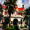
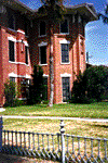 Once the wall was built, the buildings that were still standing had to
be raised because soil was dredged to fill behind the seawall. The homes
which remained along what is now Broadway street, were already on the
highest ground, so the dredging had little effect on those homes. The
fence you see in this picture of Ashton Villa was originally six feet
tall. As dredged soil was brought in, part of this fence was buried. That
six foot fence is now only thirty inches high.
Once the wall was built, the buildings that were still standing had to
be raised because soil was dredged to fill behind the seawall. The homes
which remained along what is now Broadway street, were already on the
highest ground, so the dredging had little effect on those homes. The
fence you see in this picture of Ashton Villa was originally six feet
tall. As dredged soil was brought in, part of this fence was buried. That
six foot fence is now only thirty inches high.
What do we mean by "dredging"
?
How much of the fence is buried?
What would have happened to the other houses if they hadn't been raised?
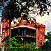
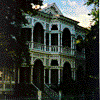
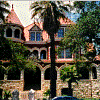
People who lived in these homes were accustomed to "calling on" or formally visiting their neighbors. Visitors would place their calling card in/on a container by the front door of the house they were visiting. A servant would take the card to the master or mistress of the house to see if they were willing to meet the visitor. If the visitor folded a certain corner of their card, they were telling the owner the visit was to extend condolences/sympathy to the family. A different folded corner would express congratulations. A young man who folded his card in half would be signifying he wished to visit with all the young ladies in the house. Such a visit was limited to fifteen minutes. Weather and opera were safe topics for young people to discuss. What topics do you discuss with your friends?
Residents slept in beds which appear to be very short, but have very high headboards. It was believed a person's lungs would fill with fluid if they slept lying down. This would lead to disease, so people slept sitting up. Research pneumonia or yellow fever.
Books to Read and Other Resources
- HANNA THE IMMIGRANT by Jan Siegel Hart; Eakin Press, 1991
- LAFITTE, THE TERROR OF THE GULF by Catherine Gonzalez; Eakin Press, 1981
- WHERE THE PIRATES ARE by Tom Townsend; Eakin Press, 1985
- THE DARK SHIPS by Tom Townsend; Eakin Press, 1986
- POWDERHORN PASSAGE by Tom Townsend; Eakin Press, 1988
- THE BALLAD
OF THE PIRATE QUEENS by Jane Yolen; Harcourt Brace & Co., l995
Web resources:
Images of Galveston by Todd A. Guillory
Maps of Galveston County (choose Galveston in county menu)
Where Wetlands Meet the Waves by Frederick T. Werner
Suggested Activity
Climate (weather over a long period) and weather (condition of the air at a specific time) directly influence our way of life. Use your computer to:
- Create a bar graph of the precipitation your area recieves during a month.
- Create a line graph of the daily temperatures for a month.
- Research the average monthly temperature OR rainfall for your area and graph the twelve readings to give a "picture" of the entire year.
What conclusion(s) can you draw about our lifestyle based on the information you have gathered?
For more information, write to:
2106 Seawall Blvd.
Galveston, TX 77550
